Monday, January 31, 2011

Thursday 29/7/2010 Poeppel Corner to Birdsville

(Poeppel Corner to Birdsville)
Packed up in drizzle this morning. We didn't leave until 0930hrs as Brian was talking to Col this morning for about 30 minutes. We headed north along the western edge of the next lake over. It was very wet mud and had to occasionally head off the lake  when it looked too boggy. It went for ever. Longer than it seemed.
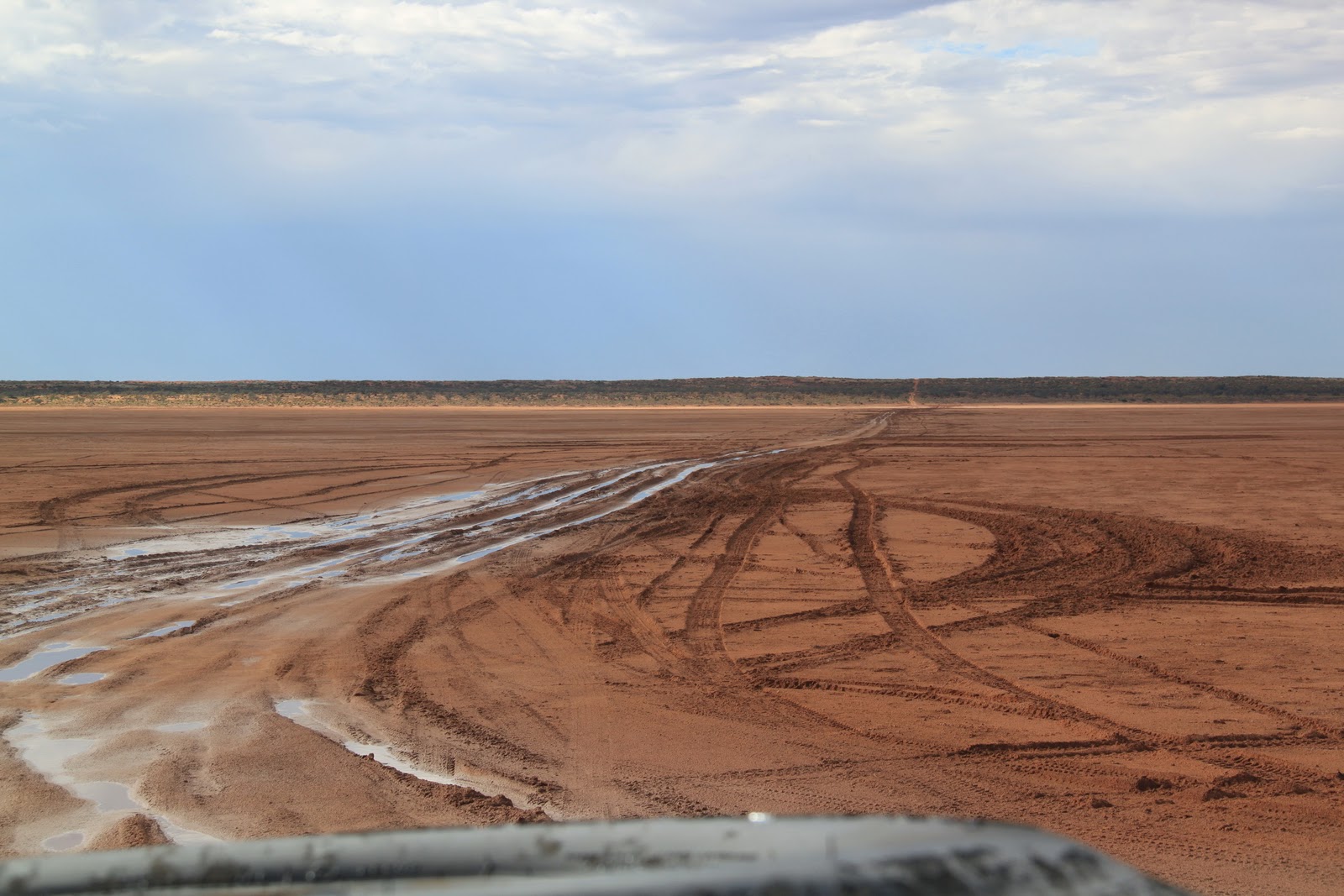
We then had to turn east, straight across the centre of the north half of the lake on the QAA Line to Birdsville. It was such a long crossing. Deep ruts, water and mud. After our previous experience we were pretty worried about getting bogged half way across. Staying in the ruts, we kept our speed up and went flying across with mud and water spraying everywhere. The longest claypan crossing we've done, and the recent downpour made it scary but fun with it getting deeper on the eastern side. I think it was getting close to needing to divert north around the top half. Brian contacted us to check if we'd made it across so he knew whether or not to try.
Wildlife galore. A black kite, 2 brown falcons, lots of budgies and gidgee trees in most swales.
There are some beautiful flowers that look like budgies. They remind me of orchids.
We've passed 2 groups so far. Everyone stops and gets info on the track ahead.
Brian's group are about 8km behind us. Lots of radio chatter.
We're seeing lots of red-tailed finches. They are big wide swales now with gidgee forests. The track seems firmer now with a clay base, with sand on the dune peaks.
Jordan had another drive, going across another small clay pan, a side track around deep mud and through some water.
Then Jack had his first turn. He did a donut off the left of the track (in slow motion). They are both brilliant drivers and would be able to get us out of trouble if needed. I think they are both pretty keen to save up for a 4WD now!
Almost at Eyre Creek. Galahs galore!
Eyre Creek is flowing. It is wild with birdlife here. Cockatiels, four kites, budgies, martins (swallows), galahs.
We stopped and chatted to an older couple camped on the eat side of Eyre Creek. They were living in a 4WD bus. She told me that the flower I saw was called "birds beak".
Further north on the creek it was crowded with campers.
It wasn't much further to Big Red.
It really was big and spectacular and really is very red sand. We drove up it without any problems, but it also probably helped that it had rained.
Most things I've read say it is steeper from the east, but it seemed about the same to us.
There is currently a massive lake on the eastern side of Big Red, with a flooded forest of trees and again, birds galore.
Ducks, doves, piwis, white cockatoo, galah, kites, other water birds and a giant eagles nest. It was a huge detour south around the lake.
It was a well graded road and a speed of 80km/hr for the remainder of the trip to Birdsville, arriving at 1700hrs, then changing our watches to 1730hrs their time.
We decided not to set up camp in the mud (clay) next to the Diamantina Billabong in the drizzly rain. A relaxing night in the Birdsville Hotel instead. It was a lovely, clean, spacious 2 bedroom apartment with a loungeroom, out the back of the Hotel. You could park right at the door and the laundry was a couple of doors away.
Showers all round (Aaahhh)! I put the washing on, then we all headed to the Hotel for dinner.
Such a nice pub. Lots of old country charm.
Apparently Innamincka is closed, even to flights at the moment due to flooding. The airstrip is underwater.
The Birdsville Track and Cordillo Downs Road (through the Sturt Stony Desert) are also closed.
The gravel road east is our only option. We aim to head for Arabury Station, then Innamincka if able.
Cameron's Corner is also closed so we may miss the Strzelecki Desert as well.
Looks like we'll have to come back out here again!

Thursday, January 27, 2011

Wednesday 28/7/2010 Lone Gum Tree to Poeppel's Corner

(Lone Gum Tree to Poeppel's Corner)
Woke up at 0700hrs to find that we couldn't see further than the first dune due to fog!!
That was certainly unexpected! Surely this is a rare occurance?
Weirdly I took a photo of a gum tree, reflected in a pool of water, surrounded by fog, in the middle of the Simpson desert!
 
There is a falcon nesting in the gum tree.
Again, the poles put in by Desert Parks to protect the Lone Gum Tree may succeed in this, but ruin the natural beauty and the feeling of remoteness. What a shame beauty needs to be protected from idiots in the first place.
The other family here have a 4yr old and a 2yr old, and have been travelling since last November.
We were packed up and ready to go at 0830hrs, but now waiting for Col to visit the seat with the best view, one dune over.
Jordan was a bit crabby for about 3 days from Alice, but has improved a lot now after a good talk. I think she was a bit homesick. Travelling with a group the other day was a lovely "pick me up" for all of us. We need some friends. It is a shame they pulled out (no surprise), leaving us to travel alone, although it has been great for family bonding.
Left the Lone Gun at 0900hrs taking the Rig Line instead of the WAA Line for the next section as the other end is under a lake at the moment. We will skirt the south end of the lake.
Anyone out there that wants an easier trip, take the Rig Road, and for fun, big sand dunes take the WAA Line.
We are seeing dingo and emu tracks and just chased a quail. Again, there are plenty of wild flowers.
It is 1000hrs, we are on the Rig Road and it is raining, the entire sky is overcast and we are looking at ducks on a pond!! This is certainly a different Simpson Desert than usual.
It was sunny again by 1100hrs.
Once heading north on Knolls Track we saw 3 camels. One was a baby. So cute.
There's the lake we had to skirt south around. Along the Knolls Track there were hundreds of bright green budgies, a forrest of gidgee trees and ridges, outcrops of sandstone. Approdinna Attora Knoll is a gypsum outcrop. It is the highest point in the Simpson and used to be a mountain, worn down over millions of years. It is surrounded by clay and salt pans. We had a lovely family shot on the salt lake.
Had lunch and walked to the top of the outcrop to see a huge front building to the SW across a clay pan. Looks like we could be in for a bit of a storm later!
We hit the French Line and turned to the east. Again, very well sign posted. It started off easy but eventually became larger sand dunes closer to the corner (a slower 40km/hr). The dunes are larger but the swales also wider. The sand here is paler, a light orange rather than red.
The front is rapidly approaching from the south. I needed to stop often to take photos. Beautiful!
A group of about 8 cars passed us. You could hear their radio chatter and see their flags well in advance. They were a self drive guided tour, heading west.
Passing a couple of cars towing 4WD camper trailers, we stopped to chat for a bit. They recognised Jordan from the King's Creek Station camel show. "It's Video Girl!" they cried and wanted a photo of her. They said they saw the show the following night as well, and her video was shown again. Apparently the owner loved it and it is a permanent part of the show! Cool, Jordan is now a famous movie producer. She was very proud of herself.
His name is Brian. I remember him from the camel show and tea around the fire as he is loud and funny, and can really spin a yarn.
After crossing a few salt pans we arrived at Poeppel's Corner at 1600hrs, all puting our hands on the corner marker to be in South Australia, Northern Territory and Queensland all at once.
The black clouds are hanging over us with blue sky to the north. A strong cold wind is blowing and we tried to get shelter behind the north side of dunes and bushes.
That evening we watched the best lightning show we'd ever seen with Brian and his crew. There was no rain but the wind was fierce.
The clouds passed. The stars came out (must have been the eye of the storm). We went to bed and the heavens opened. It absolutely poured at 0100hrs.


Tuesday 27/7/2010 Purnie Bore to the Lone Gum Tree

(Purnie Bore to the Lone Gum Tree)
All slept in till 0830hrs. Awoke to sunshine and an orchestra of bird sounds. Wow, amazing sound! It's the warmest day yet. We are wearing T-shirts and shorts, and the flies are thick.
The kids played on the dune again while I had that shower. It took a full 35 minutes for the hot water to get there!! Lovely once it did.
Well we didn't leave untill 1100hrs. Big mistake! Got to the Lone Gum Tree at 1830hrs. It was a long day. Up down, up down, up down. Absolutely beautiful though. So many flowers and much greener than we expected. No plain red dunes, but plenty of partial ones for pretty photos.
The dunes started off small, at about 5m along the French Line.
The signage was very good. It would be hard to get lost if you stick to the tracks out here.
We headed south along the Rig Road and had lunch in the swale before heading east along the WAA Line.
The swales were pretty big on the WAA line, especially just west of the Erabena Track (about 20 to 30m).
It was much wilder in there. About 3 of the swales had water across them and we had to make our own way around.
Then there was another smaller puddle on the track that looked OK, but we sank and got bogged. Col had to dig and use low range to get out. I think we should have been playing with diff lock sooner. We didn't use it at all until after we were home from this trip.
We learnt our lesson. Deffinitely stay in the well used ruts, even if the water is deeper. The mud is compacted rather than like quicksand if you veer off. It's either the main track or a much larger diversion. Our next step would have been using our fire wood to cover the mud behind us, but luckily we didn't need to.
Had to add a bit of drama to the day!
We only passed 2 groups today. First was a single man in a single vehicle. Col and Jordan new him from the Kalgoorlie car park!
Next were a group of 4 cars. One of them had a 5yr old, a 2yr old and a newborn (very brave)!
This group had been stuck in Innamincka for 2 days with a broken chassey. The mechanic kept puting them off so they borrowed a welder and reinforced it themselves.
We won't be able to continue along the WAA Line east of Erabena, as it is covered by a lake at the other end according to this group.
Everyone updates each other as they pass, learning from each other's stories. It's also quite entertaining.
The final trip south to the Lone Gum Tree was in the dark. It didn't take long as travelling south is flat in the swales.
Our average speeds today were about 15km/hr most of the way (while heading east) and getting up to 50km/hr (when heading south) in the swales. I had fun driving some of the French Line and Rig Road, but the WAA Line was the most impressive.
There were so many white wild flowers mostly topping the dunes, while the yellow flowers seem to cover the east walls of the dunes.
It was a quick setup, tea and dishes, then relax around the campfire with a glass of wine. The full moon came up at 1910hrs, huge and orange.
There is one other family camped here, about 100m away. They have little kids and went to bed early, so we didn't try to socialise.There was no wind and it wasn't cold. Col, Jordan and Jack all went to bed early but I enjoyed reading by the fire for quite some time.